


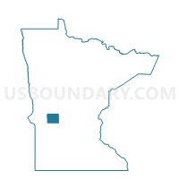
Barsness Twp. Voting District, Pope County, Minnesota
About
Outline

Summary
| Unique Area Identifier | 603750 |
| Name | Barsness Twp. Voting District |
| County | Pope County |
| State | Minnesota |
| Area (square miles) | 35.44 |
| Land Area (square miles) | 33.05 |
| Water Area (square miles) | 2.40 |
| % of Land Area | 93.24 |
| % of Water Area | 6.76 |
| Latitude of the Internal Point | 45.54567420 |
| Longtitude of the Internal Point | -95.42866210 |
Maps

Graphs
Select a template below for downloading or customizing gragh for Barsness Twp. Voting District, Pope County, Minnesota


Neighbors
Neighoring Voting District (by Name) Neighboring Voting District on the Map
- Blue Mounds Twp. Voting District, Pope County, MN
- Chippewa Falls Twp. Voting District, Pope County, MN
- Gilchrist Twp. Voting District, Pope County, MN
- Glenwood Twp. Voting District, Pope County, MN
- Langhei Twp. Voting District, Pope County, MN
- Rolling Forks Twp. Voting District, Pope County, MN
Top 10 Neighboring County Subdivision (by Population) Neighboring County Subdivision on the Map
- Glenwood township, Pope County, MN (1,058)
- Chippewa Falls township, Pope County, MN (228)
- Gilchrist township, Pope County, MN (194)
- Blue Mounds township, Pope County, MN (186)
- Langhei township, Pope County, MN (177)
- Rolling Forks township, Pope County, MN (151)
- Barsness township, Pope County, MN (149)